Ancient Mediterranean Shipyards and Harbours

Ancient Troy: Bronze Age Trade, Power, and Collapse

Ancient Troy (known to the Hittites as Wilusa) was a major Bronze Age maritime, economic, and political powerhouse located at the mound of Hisarlik in modern Çanakkale Province, Turkey (39°57′27″N 26°14′20″E). Continuously occupied from c. 3000 BC to its violent destruction around 1180 BC, Troy controlled the Dardanelles (Hellespont), a vital maritime chokepoint connecting the Aegean Sea to the Black Sea. Rather than just the mythological setting of Homer's epic, archaeological and Hittite textual evidence proves Troy was a wealthy geopolitical nexus that collapsed during the wider Late Bronze Age systems collapse.

By Nick Nutter | Published: | Updated:

Visited 360 times

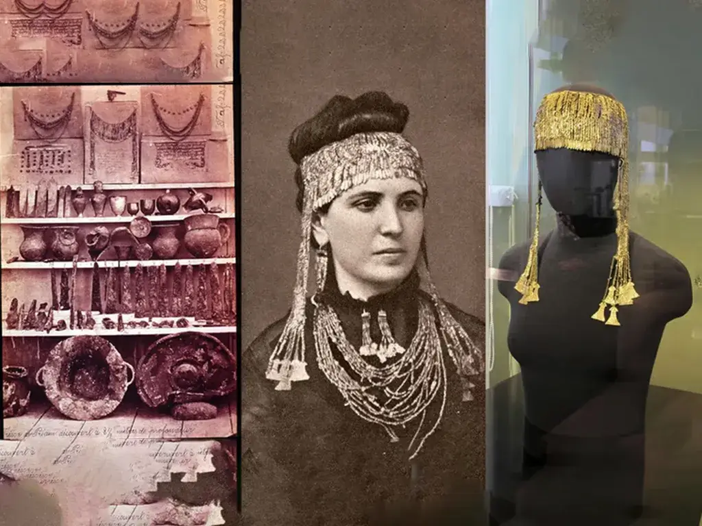
Ancient Troy: Bronze Age Trade, Power, and Collapse - Sophia Schliemann wearing Priam's Treasure
Sophia Schliemann wearing Priam's Treasure

Troy as a Bronze Age Trade, Political, and Maritime Power

Troy’s importance in the Bronze Age rested on the interaction of geography, exchange, and interstate politics. Troy's position near the Dardanelles gave the settlement leverage over maritime movement between the Aegean Sea, Anatolia (modern Asian Turkey, 39°00′N 35°00′E), and the Black Sea; the site's material record shows participation in long-distance trade; and Hittite texts place Wilusa (Troy) within the political struggles of the Late Bronze Age (Morris, 2005; Beckman, 1999; Korfmann, 2003).

Taken together, these strands show that Troy was not simply the mythological setting of later epic tradition. Troy was a fortified urban settlement whose economic and political significance developed over time and whose violent destruction belongs within the wider systems collapse of the Late Bronze Age eastern Mediterranean (34°00′N 28°00′E) (Cline, 2014; Beckman, Bryce and Cline, 2012).

Troy’s geopolitical significance rested on three linked foundations:

  • Geography: Troy's position near the Dardanelles gave the city leverage over maritime movement between the Aegean Sea, Anatolia, and the Black Sea (Korfmann, 2003).
  • Exchange: Archaeological finds show Troy’s active participation in long-distance trade networks moving metals, prestige goods, and technologies across Eurasia (Bachhuber, 2009; Bobokhyan, 2009; Muhly, 1985).
  • Politics: In the Late Bronze Age, Wilusa (Troy) was drawn into HittiteAhhiyawan (Mycenaean Greek) rivalry, helping explain why the city became central to later cultural traditions of conflict (Beckman, Bryce, and Cline, 2012; Bryce, 2005).

Where is Ancient Troy? The Strategic Geography of Hisarlik

The archaeological site of Troy lies at Hisarlik in modern Çanakkale Province, Turkey, roughly 5 kilometres (3 miles) from the present Aegean Sea shoreline. Troy's importance in antiquity derived not simply from its local setting, but from the city's strategic position near the Dardanelles, the narrow waterway linking the Aegean Sea to the Sea of Marmara (40°41′12″N 28°19′43″E) and, beyond that, to the Black Sea (Korfmann, 2003; Morris, 2005).

Because Bronze Age seafaring depended on winds, currents, and safe anchorages, settlements near maritime chokepoints could directly influence maritime movement. Troy’s location therefore gave the settlement immense leverage over shipping traffic moving between the Aegean Sea and the eastern Mediterranean (Korfmann, 2003; Morris, 2005).

Controlling the Dardanelles: Troy's Maritime Chokepoint

In antiquity, the Dardanelles (the Hellespont) formed a key maritime bottleneck. Troy stood at the meeting point of trade routes linking the Aegean Sea, Anatolia, and the Black Sea basin, placing Troy in a strong geopolitical position to mediate commercial exchange and maritime movement (Korfmann, 2003; Morris, 2005).

Ancient merchant ships often had to wait for favourable wind and current conditions before attempting to navigate the strait. Troy, situated near the southern approach of the Dardanelles, could provide safe anchorage, provisioning services, and, potentially, impose taxation controls on passing cargoes. This geographic advantage helps explain why Troy appears not as an isolated citadel, but as a wealthy urban settlement whose prosperity was explicitly tied to regional flows of metals, prestige goods, and people (Bobokhyan, 2009; Korfmann, 2003).

The Shifting Coastline

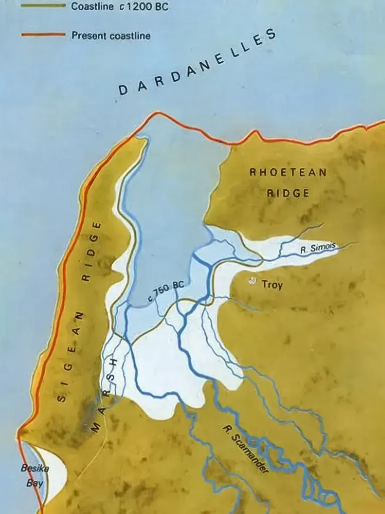
Today, Troy appears inland above a broad plain, sitting roughly 5 kilometres (3 miles) from the Aegean Sea coast. In the Bronze Age, however, Troy stood closer to a sheltered bay that functioned as a natural harbour, giving the site a much clearer maritime setting than the modern landscape suggests (Korfmann, 2003).

Over time, alluvial deposits from the Scamander (modern Karamenderes, 39°57′24″N 26°14′32″E) and Simois (modern Dümrek Su, 39°59′00″N 26°15′00″E) rivers filled this bay, gradually converting the former Bronze Age harbour into the flat agricultural plain visible today. This long geological process helps explain both Troy’s earlier maritime role and the difficulty later travellers had in reconciling Homer's epic descriptions with the inland appearance of the ruins (Morris, 2005; Korfmann, 2003).

Standing on the mound at Hisarlik today, you look out over roughly 5 kilometres of flat, agricultural land to reach the Aegean Sea. It takes quite a leap of imagination to mentally strip away all that silt and picture the Bronze Age shoreline sitting right at the foot of the ridge.

Ancient Troy: Bronze Age Trade, Power, and Collapse - Map showing position of ancient Troy and modern coastline
Map showing position of ancient Troy and modern coastline

Early Settlement and Urban Development of Troy

Troy was occupied as a fortified urban centre for roughly four millennia, beginning in the Early Bronze Age around 3000 BC. This long sequence of continuous architectural rebuilding at Hisarlik has made the Anatolian settlement central to academic debates about ancient urbanisation, regional maritime exchange, and the complex relationship between physical archaeology and later Greek literary tradition (Morris, 2005; Korfmann, 2003).

Early excavators such as Heinrich Schliemann and Wilhelm Dörpfeld focused mainly on the upper citadel, encouraging the initial academic view that Troy had been only a compact, fortified hilltop. Later archaeological excavations, especially those led by Manfred Korfmann, identified a much larger lower city and extensive rock-cut defensive features extending far beyond the main citadel. This revised archaeological picture proves that Troy was a substantial, highly populated urban metropolis rather than a minor regional outpost (Morris, 2005; Korfmann, 2003).

Early Bronze Age Wealth and Long-Distance Trade (c. 2600 – 2300 BC)

During the Early Bronze Age (c. 2600 – 2300 BC), Troy’s early economic prosperity was deeply tied to maritime exchange. During the archaeological phase known as Troy II, the urban settlement expanded, strengthened its defensive fortifications, and accumulated immense wealth. Treasure deposits, metal objects, and standardised balance weights point to local production, long-distance trade, and the management of valuable goods on a significant scale (Bachhuber, 2009; Bobokhyan, 2009).

During Troy II, the upper citadel of Hisarlik was enlarged and dominated by large megaron-style buildings, while a lower settlement developed beyond the citadel walls. The extraordinary hoards discovered in this early stratigraphic level led Heinrich Schliemann to mistakenly identify the site with Homeric Troy and to label one specific cache "Priam’s Treasure." Modern radiocarbon chronology, however, shows that these Early Bronze Age finds belong to a much earlier period, more than a full millennium before the traditional date of the Trojan War (Traill, 2000; Bachhuber, 2009).

Artefacts of Troy II: The Reality of "Priam's Treasure"

Although Schliemann presented “Priam’s Treasure” as a single royal hoard, modern scholarship now treats the discovery more cautiously, noting that the physical finds were likely composite caches and that their archaeological contexts were severely compromised by nineteenth-century excavation methods (Traill, 2000; Bachhuber, 2009).

Even so, the Troy II assemblage remains historically important because the artifacts demonstrate the range and quality of materials circulating through early Troy:

  • Jewellery and adornment: Gold diadems, earrings, bracelets, and thousands of small gold pieces indicate highly skilled metallurgical metalworking and elite display (Traill, 2000).
  • Vessels and feasting equipment: Gold, silver, electrum, and copper containers suggest ceremonial consumption as well as stored material wealth (Bachhuber, 2009).
  • Prestige materials: Polished stone hammer-axes and other exotic objects point to long-distance trade connections reaching far beyond north-western Anatolia (Muhly, 1985).

Taken together, these artifact finds suggest that early Troy was not merely prosperous by local standards. Troy actively participated in long-distance networks through which raw metals, crafted goods, and prestige materials circulated between Anatolia, the Aegean Sea, the Caucasus (42°00′N 43°30′E), and regions farther east. Materials such as Afghan lapis lazuli and Baltic amber are especially important because they imply commercial connections extending well beyond the immediate eastern Mediterranean (Muhly, 1985; Singer, 2016).

Bronze Age Trade Networks: Troy and the Black Sea

The Black Sea formed an important northern extension of Troy’s maritime world. Rather than relying on formal stone-built port cities, Bronze Age exchange in the Black Sea region seems to have moved through natural anchorages, river mouths, and coastal nodes that linked maritime ship traffic to inland resources and pastoral communities (Morris, 2005; Korfmann, 2003).

Selected Regional Connections

  • The Caucasus and eastern Black Sea (modern Georgia, 42°00′N 43°30′E): Troy’s metalworking and prestige goods suggest direct maritime ties to regions rich in gold, copper, and technical expertise. Scholarly comparisons have long connected some of the more distinctive ceremonial stone objects from Troy to Caucasian traditions, implying movement not only of raw materials but also of artisanship and ideas (Muhly, 1985).
  • The northern Black Sea and Pontic steppe (47°00′N 34°00′E): Contacts with the Pontic zone may help explain the movement of domesticated horses, hides, timber, and possibly amber. The increasing prominence of horse bones in later Trojan archaeological contexts has often been linked to wider northern Eurasian exchange networks.
  • The western Black Sea and Danube corridor (modern Romania, 45°50′N 25°00′E, and Bulgaria, 42°45′N 25°30′E): The Danube River (45°13′N 29°40′E) system provided a prehistoric superhighway by which materials from central and northern Europe could move southward to the coast. Ceramic links and later population movements suggest that Troy remained economically tied to this western zone even after major destructions (Morris, 2005; Korfmann, 2003).
  • The northern Anatolian coast: Coastal links along the southern Black Sea connected Troy to local Anatolian resource zones and safe anchorages farther east, reinforcing Troy's role as part of a broader maritime corridor rather than an isolated endpoint (Morris, 2005; Korfmann, 2003).

Into the Iron Age

These maritime trade routes did not vanish with the end of the Bronze Age. Later Iron Age Greek communities expanding into the Black Sea exploited many of the exact same anchorages and river corridors, suggesting that Iron Age expansion built directly upon an older maritime geography in which Troy had already played an important intermediary role for centuries (Morris, 2005).

The Dark Age of Troy III–V (c. 2300 – 1750 BC)

The violent destruction of the wealthy Troy II settlement around 2300 BC marked a major geopolitical turning point, plunging the city into a centuries-long period of economic and architectural decline known as the Dark Age of Troy III–V. The monumental architecture and concentrated wealth of the earlier phase were not simply restored; instead, the archaeological phase of Troy III presents a denser, poorer, and more defensive urban settlement pattern, suggesting a prolonged period of contraction and insecurity (Blegen et al., 1950; Easton, 2002).

This demographic and economic contraction at Troy fits a broader historical pattern of disruption across western Anatolia and the Aegean Sea near the end of the Early Bronze Age. This era is often associated with severe climatic stress (probably related to the 4.2-kiloyear BP event), mass human migration, and systemic geopolitical change. Troy survived the collapse, but for several centuries the settlement seems to have functioned on a much more modest scale before economically recovering in the Middle Bronze Age (Massa & Şahoğlu, 2015).

By the time of the Troy IV and especially Troy V archaeological phases, living conditions began to improve. Housing became less cramped, the physical settlement expanded outward again, and Troy's material culture shows stronger economic integration with the Anatolian mainland. These transitional centuries laid the essential urban foundations for the large-scale architectural rebuilding and political prominence of Troy VI (Morris, 2005; Korfmann, 2003).

Troy VI and the Rise of Wilusa (c. 1750 – 1300 BC)

During the Late Bronze Age (c. 1750 – 1300 BC), the archaeological phase of Troy VI marked the urban settlement's clearest architectural and geopolitical high point. Troy's massive limestone fortifications, expanded lower settlement area, and strategic control of the Dardanelles indicate a community with immense wealth and political weight. In Hittite texts from central Anatolia, this later iteration of Troy is generally identified with Wilusa, a regional polity important enough to appear as a major player in the diplomatic record of the Late Bronze Age (Beckman, 1999; Bryce, 2005a).

The upper citadel of Troy VI was completely rebuilt with monumental limestone fortification walls featuring battered (sloping) faces and complex designed gateways. Meanwhile, modern archaeological excavations around the Hisarlik mound indicate a much larger lower settlement, surrounded by a rock-cut defensive ditch, than earlier scholars had assumed. Together, these architectural features imply a sprawling urban centre whose civilian population and military defensive capacity far exceeded that of a small hilltop fortress (Korfmann, 2003; Morris, 2005).

Other archaeological indicators also point to Troy VI’s wider geographic reach. Domesticated horse remains become significantly more common in the faunal record, suggesting Troy's active participation in broader Eurasian military and transport systems. Concurrently, the widespread circulation of Anatolian Grey Ware pottery signals the city’s deep integration into regional production and maritime exchange networks. By the thirteenth century BC, Wilusa (Troy) was a heavily fortified metropolis positioned not only to profit from international trade but also to matter diplomatically on the world stage (Allen, 1990; Tiboni, 2021).

The Alaksandu Treaty: Troy as the Hittite Vassal "Wilusa"

By the later phases of Troy VI (the late thirteenth century BC), Wilusa (Troy) occupied a precarious geopolitical position between the Hittite Empire (centred at Hattusa, 40°01′11″N 34°36′55″E) and the Ahhiyawan (Mycenaean Greek) world across the Aegean Sea (modern Mainland Greece, 38°00′N 23°00′E). Troy's rulers were highly useful to the Hittites as local administrative partners in north-western Anatolia, but this exact strategic geography made Wilusa highly vulnerable to inter-imperial rivalry across the Aegean (Beckman, 1999; Bryce, 2005a).

The clearest historical evidence for Wilusa’s subordinate geopolitical status comes from the Alaksandu Treaty (catalogued as CTH 76), drawn up between the Hittite Great King Muwatalli II and King Alaksandu of Wilusa around 1280 BC. The cuneiform text presents Wilusa as a formal Hittite vassal state whose ruler received diplomatic recognition and military protection in return for total loyalty, troop support, and cooperation against political unrest in western Anatolia (Beckman, 1999; Bryce, 2005a).

  • Recognition of rulership and succession: The Hittite Great King officially guarantees King Alaksandu’s position on the throne and the political legitimacy of his chosen heir.
  • Military obligations: Wilusa is strictly expected to provide soldiers to support Hittite military campaigns and regional defence initiatives.
  • Political loyalty: The treaty requires the immediate reporting of anti-Hittite rebel activity and explicitly forbids the city from harbouring political fugitives.
  • Religious sanction: Local and imperial gods are invoked as divine witnesses, reflecting the sacred, legally binding status of Bronze Age diplomatic agreements.

One notable feature of the Alaksandu Treaty is its invocation of the local god Apaliunas on behalf of Wilusa. Many historical scholars and philologists associate this name with an early Anatolian precursor to the Greek god Apollo, a linguistic link often cited as one of the clearest points of contact between the historical, administrative world of Wilusa and later Greek mythological tradition about Troy (Beckman, 1999; Latacz, 2004).

Archaeological evidence also hints at the high level of administrative complexity required to manage such treaties within late Bronze Age Troy. A biconvex bronze seal bearing Luwian hieroglyphs, discovered in a later Trojan stratigraphic level, has been interpreted as tangible physical evidence for scribal and bureaucratic practices consistent with a politically organised regional centre (Tiboni, 2021).

Earthquake, Rebuilding, and the Militarisation of Troy VIIa

The destruction of the wealthy Troy VI settlement at Hisarlik was likely caused by a massive earthquake rather than by a direct military assault. Structural damage within the archaeological record suggests that a violent seismic event, striking sometime after 1300 BC, brought down large sections of the city’s monumental limestone architecture (Hough and Bilham, 2006; Korfmann, 2003).

Following the earthquake, the urban centre was quickly rebuilt as the archaeological phase known as Troy VIIa, but in a markedly different, highly militarised form. Domestic houses were packed much more tightly within the surviving citadel walls, large pithoi (storage jars) were sunk deep into the floors to stockpile rations, and the lower city’s rock-cut defensive ditch remained a critical fortification. These drastic urban planning changes suggest a Trojan community increasingly concerned with food security, military defence, and the imminent possibility of a prolonged siege (Blegen et al., 1958; Korfmann, 2003).

Wilusa, Ahhiyawa, and the Possibility of War

Hittite cuneiform texts from the Late Bronze Age provide the primary historical evidence that Wilusa (Troy) was directly involved in military and political conflicts with Ahhiyawa, an empire widely identified by modern scholars as the Mycenaean Greek world. While these diplomatic archives do not recount Homer’s epic Trojan War verbatim, they conclusively prove that Wilusa was a highly contested flashpoint in a prolonged geopolitical proxy war across western Anatolia during the thirteenth century BC (Beckman, Bryce and Cline, 2012; Bryce, 2005b).

The Tawagalawa Letter (catalogued as CTH 181, written c. 1250 BC by the Hittite Great King Hattusili III) explicitly refers to a past military disagreement over Wilusa that had been temporarily settled. Meanwhile, the Manapa-Tarhunta Letter (catalogued as CTH 191, written c. 1295 BC) associates the Trojan region with the aggressive regional activities of Piyamaradu, a disruptive local warlord intimately linked to anti-Hittite unrest and suspected of receiving Ahhiyawan backing. Taken together, these historical documents suggest that Wilusa was repeatedly drawn into wider imperial contests for influence, explicitly including violent conflicts in which Mycenaean Greek interests were actively involved (Beckman, Bryce and Cline, 2012; Bryce, 2005b).

How Was Troy Destroyed? Evidence of the Siege of Troy VIIa

Around 1180 BC, the heavily militarised settlement of Troy VIIa at Hisarlik was violently destroyed in circumstances that modern archaeologists overwhelmingly interpret as a hostile military sack. This catastrophic event effectively ended the city's reign as a Late Bronze Age geopolitical powerhouse. The physical archaeological evidence for this siege includes unburied human remains found sprawled in the streets, extensive fire damage across the citadel, bronze Aegean-style arrowheads embedded in the masonry, and stockpiles of sling stones left unused near the limestone defensive walls (Cline, 2013; Blegen et al., 1958).

While no single surviving historical text explicitly proves that the Mycenaean Greeks (Ahhiyawa) destroyed Troy, the convergence of physical archaeological destruction evidence and Hittite diplomatic references to prolonged conflict over Wilusa makes that specific military scenario historically plausible. At minimum, the fiery end of Troy VIIa belongs within a wider geopolitical landscape of warfare and systemic instability affecting the eastern Mediterranean during the late thirteenth and early twelfth centuries BC (Cline, 2014; Beckman, Bryce, and Cline, 2012).

Why Troy Was Not Rebuilt Immediately

If Troy fell to a Mycenaean-led military attack around 1180 BC, the Greek victors were in no position to consolidate their success or rebuild the ruined city for long. At roughly the exact same time, the highly centralized palatial world of Mycenaean Greece was itself undergoing a catastrophic systemic collapse, with major administrative centres such as Pylos (37°01′37″N 21°41′41″E), Mycenae (37°43′51″N 22°45′22″E), and Tiryns (37°35′58″N 22°47′59″E) suffering violent destruction and their wider bureaucratic systems completely disintegrating (Dickinson, 2006; Cline, 2014).

Simultaneously, the protective Hittite Empire across central Anatolia was also violently breaking apart. Recent paleoclimatology research has identified a severe, multi-year megadrought in central Anatolia spanning roughly 1198–1196 BC, while contemporary textual and archaeological evidence points to simultaneous military invasion, political fragmentation, and administrative breakdown. With the imperial heartland of Hatti completely collapsing, western Anatolian vassals such as Wilusa (Troy) could no longer rely on external imperial protection, economic aid, or post-war reconstruction (Manning et al., 2023; Bryce, 2005a).

Troy and the Late Bronze Age Collapse

The violent destruction of Troy around 1180 BC is best understood within the wider historical context of the Late Bronze Age systems collapse. Troy depended on the exact same interconnected geopolitical and economic systems that made the urban settlement so valuable: international maritime exchange through the Dardanelles, regional diplomacy, and imperial competition between larger powers like the Hittite Empire and the Mycenaean Greeks. When those global systems came under severe pressure from widespread warfare, disrupted trade networks, severe environmental stress, and total administrative failure, Troy lost both the commercial networks that enriched the city and the imperial states that might have protected or rebuilt the ruins (Cline, 2014; Manning et al., 2023).

Troy therefore matters historically not simply because later Greek literary tradition made the city famous, but because the physical archaeological and surviving textual records explicitly place the Anatolian settlement at the vital intersection of geography, maritime exchange, and interstate politics. Troy's multi-millennial history demonstrates how absolute control of maritime movement and access to Eurasian trade networks could produce immense urban growth and diplomatic relevance, while simultaneously guaranteeing the city's ultimate vulnerability to wider systemic collapse.

Legacy of "Priam’s Treasure"

The modern history of the Early Bronze Age artifact cache known as “Priam’s Treasure” is almost as contentious as the collection's ancient archaeological interpretation. After the German excavator Heinrich Schliemann removed the Troy II gold finds from the Ottoman Empire (centred at Constantinople, 41°00′N 28°57′E) in 1873, the collection passed through Berlin (52°31′12″N 13°24′18″E) and, after the Second World War, into Soviet hands. The Soviet Union (modern Russia, centred at Moscow, 55°45′N 37°37′E) consistently denied possessing the Trojan artifacts. It was not until 1993, following the geopolitical collapse of the USSR, that the Russian government officially admitted the Troy gold was safely stored in museum vaults. The hoard finally went on public display in 1996 and is now held primarily in the Pushkin State Museum of Fine Arts in Moscow (55°44′50″N 37°36′20″E), while related Trojan artefacts and replicas remain divided among various institutions in Germany and Turkey (Traill, 2000).

The Troy Museum (Troya Müzesi), located in Çanakkale, Turkey (39°57′18″N 26°14′49″E), was opened in 2018 just a few kilometres from the actual archaeological site of Hisarlik. This state-of-the-art museum houses many artifacts scientifically excavated from Troy. The Turkish government has successfully repatriated several smaller Trojan gold pieces from museums in the United States (38°53′N 77°02′W) and the United Kingdom (51°30′N 0°07′W) to display at the Troya Müzesi, and Turkish officials maintain an active legal and diplomatic campaign demanding that Russia return the Schliemann hoard to its country of origin.

When visiting the Troya Müzesi today, located just down the road from the Hisarlik excavation site, you can get a close look at several of these repatriated Trojan gold pieces. Seeing the intricate Bronze Age metallurgy up close really drives home just how wealthy and technologically advanced this Early Bronze Age society actually was.

The modern global distribution of these excavated artifacts from Troy continues to actively shape international museum debates about provenance, legal restitution, and the rightful ownership of global archaeological heritage.

References

  • Bachhuber, C. (2009) ‘The treasure deposits of Troy: rethinking crisis and agency on the Early Bronze Age citadel’, Anatolian Studies, 59, pp. 1–18.
  • Beckman, G. (1999) Hittite diplomatic texts. 2nd edn. Atlanta: Scholars Press.
  • Beckman, G., Bryce, T. and Cline, E.H. (2012) The Ahhiyawa texts. Atlanta: Society of Biblical Literature.
  • Blegen, C.W., Caskey, J.L. and Rawson, M. (1950) Troy: general introduction, the first and second settlements. Princeton, NJ: Princeton University Press.
  • Blegen, C.W., Boulter, C.G., Caskey, J.L. and Rawson, M. (1958) Troy: settlements VIIa, VIIb and VIII. Princeton, NJ: Princeton University Press.
  • Bobokhyan, A. (2009) ‘Trading implements in early Troy’, Anatolian Studies, 59, pp. 19–50.
  • Bryce, T. (2005a) The Kingdom of the Hittites. 2nd edn. Oxford: Oxford University Press.
  • Bryce, T. (2005b) The Trojans and their neighbours. London: Taylor & Francis.
  • Cline, E.H. (2013) The Trojan War: a very short introduction. Oxford: Oxford University Press.
  • Cline, E.H. (2014) 1177 B.C.: the year civilization collapsed. Princeton, NJ: Princeton University Press.
  • Dickinson, O. (2006) The Aegean from Bronze Age to Iron Age: continuity and change between the twelfth and eighth centuries BC. London: Routledge.
  • Easton, D.F. (2002) Schliemann’s excavations at Troia 1870–1873. Mainz: Philipp von Zabern.
  • Hough, S.E. and Bilham, R.G. (2006) After the earth quakes: elastic rebound on an urban planet. New York: Oxford University Press.
  • Korfmann, M. (2003) ‘Troia im Lichte der neuen Forschungsergebnisse’ [Troy in the light of new research results], in Troia: Traum und Wirklichkeit. Stuttgart: Theiss.
  • Latacz, J. (2004) Troy and Homer: towards a solution of an old mystery. Oxford: Oxford University Press.
  • Morris, I.P. (2005) ‘Troy and Homer’, Princeton/Stanford Working Papers in Classics, November.
  • Muhly, J.D. (1985) ‘Sources of tin and the beginnings of bronze metallurgy’, American Journal of Archaeology, 89(2), pp. 275–291.
  • Singer, G.N.G. (2016) ‘Amber exchange in the Late Bronze Age Levant in cross-cultural perspective’, Aula Orientalis, 34(2), pp. 251–264.
  • Tiboni, F. (2021) The hippos of Troy. Oxford: Archaeopress Publishing.
  • Traill, D.A. (2000) ‘Priam’s Treasure’: clearly a composite, Anatolian Studies, 50, pp. 17–35.

Enjoying the fast, clean reading experience?

Discover how I partnered with an AI to rescue this outdated site from technical debt and hit perfect 100/100 Lighthouse scores. Legacy Reloaded is the ultimate guide to modernising old code without losing your mind.

Location Map

Location Map